| WPC Met Watch |
|
|
Mesoscale Precipitation Discussion: #0882 (2018) |
|
(Issued at 200 PM EDT Sat Sep 22 2018
) |
|
| MPD Selection |
|
|
|
|
|

Mesoscale Precipitation Discussion 0882
NWS Weather Prediction Center College Park MD
200 PM EDT Sat Sep 22 2018

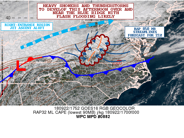
Areas affected...Western and Southwest VA including the Blue Ridge

Concerning...Heavy rainfall...Flash flooding likely

Valid 221800Z - 230000Z

Summary...Slow-moving showers and thunderstorms will be developing
very soon, and will produce heavy rainfall totals this afternoon
and evening. Flash flooding will be likely along the Blue Ridge.

Discussion...A cold front continues to settle south down across
the Mid-Atlantic region this afternoon in response to high
pressure moving across the Great Lakes region. However, in the
wake of this frontal passage, the model guidance is strongly
supporting the development of a weak inverted trough along or just
east of the Blue Ridge over the next few hours as the boundary
layer flow just off to the east over the coastal plain sharply
veers. This is expected to greatly enhance the low level moisture
convergence into the higher terrain of the Blue Ridge including
adjacent areas of the Piedmont just to the east.

The increasing moisture convergence over the terrain coupled with
orographic forcing, some modest right entrance region jet dynamics
ahead of a shortwave trough over the TN Valley, and a modestly
unstable airmass with MLCAPE values near 1000 j/kg will set the
stage for numerous showers and thunderstorms to develop this
afternoon. There will be a tendency for the convection to be
anchored over the terrain and with some small scale repeating of
cells likely. This coupled with slow cell motions in general will
set the stage for some very heavy rainfall totals.

The PWATs across the region are expected to be 1.5 to 2 standard
deviations above normal going through the afternoon and evening
hours with values of 1.5 to 1.6 inches. The environment will be
conducive to relatively warm-topped convection, but with highly
efficient rainfall processes given the focused moisture
convergence.

Rainfall totals may exceed 2 inches/hr, and the latest HREF and
HRRR-tle probabilistic guidance strongly supports these rates in
particular between 21Z and 00Z. Overall, expect the potential for
as much as 4 to 6 inches of rain locally through 00Z, which given
the wet antecedent conditions is likely to cause flash flooding.
This will especially be the case given the locally steep terrain.

Orrison

ATTN...WFO...LWX...RLX...RNK...

ATTN...RFC...MARFC...OHRFC...SERFC...

LAT...LON   38527899 38237877 37417910 36637974 36498025
            36638072 36988078 37778024 38417966
Last Updated: 201 PM EDT Sat Sep 22 2018
|


