| WPC Met Watch |
|
|
Mesoscale Precipitation Discussion: #0880 (2018) |
|
(Issued at 206 AM EDT Sat Sep 22 2018
) |
|
| MPD Selection |
|
|
|
|
|

Mesoscale Precipitation Discussion 0880
NWS Weather Prediction Center College Park MD
206 AM EDT Sat Sep 22 2018

Areas affected...Northeast Texas, Southeast Oklahoma, Southwest
Arkansas

Concerning...Heavy rainfall...Flash flooding likely

Valid 220605Z - 221200Z

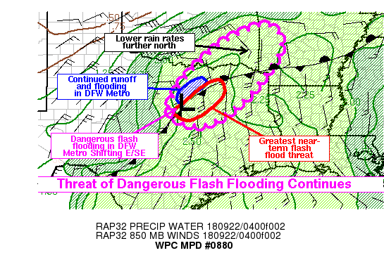
Summary...The threat of dangerous flash flooding will continue
through the early morning hours, particularly in parts of
Northeast Texas. Significant flash flooding has been reported
already in the DFW Metro Area, and the thunderstorms responsible
for this flash flooding should be shifting east and southeast
soon. This should cause additional areas of flooding to develop
further southeast. Rain rates will be lower into portions of
southeast Oklahoma and southwest Arkansas, but some of these areas
have already received heavy rainfall in the past 24 hours, and may
be more vulnerable to flooding even with steadier rain.

Discussion...KFWS radar has been tracking a weak mesovortex
drifting slowly to the northeast through Tarrant County as of 06Z,
and this had helped focus a band of extremely heavy rain right in
the DFW metro area over the prior two hours. This downstream
convection (NE of the mesovortex) was beginning to weaken, perhaps
as access to instability becomes increasingly restricted.
Nevertheless, the recent heavy rainfall has been sufficient to
cause widespread, dangerous flash flooding in much of the DFW
metro area, and flooding issues should continue for at least
another couple hours even if rain rates continue to decrease.
However, on the southeast flank of the mesovortex, an elongated
convective band has developed from Dallas southwest to near
Cleburne. This was occurring near the interface of unstable SSE
inflow and more stable, rain-cooled air mass to the northwest.
This may lead to some continued training, but the rain band is not
aligned exactly parallel to the mean flow. The slight angle,
combined with the motion of the mesovortex, should lead to a
gradual east or southeast expansion of the heavy rain in the next
few hours, and this should be the greatest threat of dangerous
flash flooding over that time frame. This would include areas from
Cleburne and Hillsboro, northeast to Dallas and Kaufman. Rain
rates in this convective band could reach 2-3 in/hr at times with
access to (RAP analyzed) MLCAPE around 1000 j/kg and precipitable
water around 2.3 to 2.4 inches.

Meanwhile, rain rates should generally be limited to the immediate
northwest of this rain band (SSE inflow will be intercepted by the
convection) and further north into parts of OK and AR where
instability will also be limited. Some parts of southeast Oklahoma
have already received several inches of rain, so even lower rain
rates could lead to a continuation or expansion of flooding in
some areas. Furthermore, RAP analysis does show some elevated CAPE
on the order of 500-800 j/kg into these areas, so some convective
rain bands will be possible and rain rates may locally exceed 1
in/hr at times.

Lamers

ATTN...WFO...FWD...LZK...OUN...SHV...TSA...

ATTN...RFC...ABRFC...LMRFC...WGRFC...

LAT...LON   35509408 34549361 32789479 31919582 31419689
            31959810 32939771 33919691 34969559
Last Updated: 206 AM EDT Sat Sep 22 2018
|


