| WPC Met Watch |
|
|
Mesoscale Precipitation Discussion: #0678 (2018) |
|
(Issued at 808 PM EDT Thu Aug 16 2018
) |
|
| MPD Selection |
|
|
|
|
|

Mesoscale Precipitation Discussion 0678
NWS Weather Prediction Center College Park MD
808 PM EDT Thu Aug 16 2018

Areas affected...Portions of the Desert Southwest

Concerning...Heavy rainfall...Flash flooding possible

Valid 170007Z - 170407Z

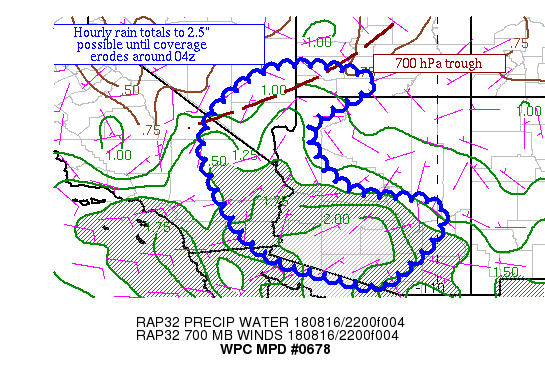
Summary...Ongoing convection is expected to lead to hourly rain
rates up to 2.5" until convection fades around 04z.

Discussion...An active monsoon day has unfolded due to greater
than average moisture interacting with an upper trough across CA
and northwest NV.  Precipitable water values of 2-2.2" across
southwest AZ, with 1-1.4" amounts across southern NV and the
Mogollon Rim set the stage for an early onset around 18z.  Radar
trends show a trend towards convective concentration across
southern AZ and far southwest CA/southern NV as of late.  MU CAPE
values of 1500-2500 J/kg lie across the area.  Inflow at 700 hPa
is fairly weak, but concentrating most into a trough across
southern NV and southwest UT.  Effective bulk shear is < 25 kts
per SPC mesoanalyses.

The presence of the nearby upper trough complicates the forecast
as it may tap the instability aloft, which would allow convection
to hold on for several more hours.  The 700 hPa trough drifts
southward into northwest AZ and down the Lower Colorado River
Valley over the next few hours per RAP forecasts.  The mesoscale
guidance expects the activity to wane around 03z.  The bulk of the
initial shortwave aloft should be progressive well north of the
area, exerting less of an influence beyond 03z.  Coordination with
VEF/Las Vegas NV led to a compromise 04z timing for the end of the
MPD for when instability should be sufficiently erodes and
divergence aloft lessens.  Until then, thunderstorms may tend to
congregate/merge across the Desert Southwest as well as southern
NV and southwest UT, depositing hourly rain totals up to 2.5"
where cells merge or move little.

Roth

ATTN...WFO...FGZ...PSR...SLC...TWC...VEF...

ATTN...RFC...CBRFC...CNRFC...

LAT...LON   37751473 37421190 36151370 34341266 33871004
            32791029 31661158 31641193 32381459 33581588
            35971663
Last Updated: 808 PM EDT Thu Aug 16 2018
|


