| WPC Met Watch |
|
|
Mesoscale Precipitation Discussion: #0624 (2018) |
|
(Issued at 519 AM EDT Fri Aug 10 2018
) |
|
| MPD Selection |
|
|
|
|
|

Mesoscale Precipitation Discussion 0624
NWS Weather Prediction Center College Park MD
519 AM EDT Fri Aug 10 2018

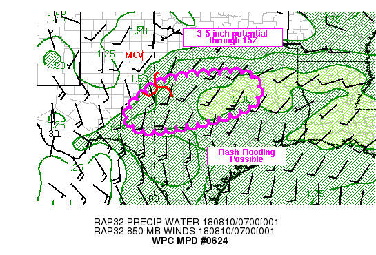
Areas affected...central TX

Concerning...Heavy rainfall...Flash flooding possible

Valid 100918Z - 101440Z

Summary...Heavy rainfall should expand across portions of central
TX over the next 2-3 hours with a threat for flash flooding
forecast through 14Z despite dry antecedent conditions. There will
be potential for 3-5 inches of rain by 15Z.

Discussion...GOES 16 "clean window" IR imagery showed a remnant
MCV spinning over west-central TX at 0830Z, located between ABI
and SJT. As has been advertised in a majority of the hi-res
models, convection appears to be expanding in coverage and
intensity with the strongest storm located over McCulloch county
as of 0845Z. The environment as sampled by area GPS sites shows
precipitable water values ranging between 1.8 and 2.1 inches along
with a 200-600 J/kg increase in CAPE over the past 3 hours
coincident with newly developing storms with the 08Z SPC
mesoanalysis page showing 500-2000 J/kg MUCAPE as of 08Z. Flow
aloft was diffluent, with the axis of contraction and associated
enhancement to vertical motion situated over the developing
convection.

Average storm motions have been off toward the east or northeast
at 5-15 kt and locally enhanced southwesterly 850 mb flow of 15-25
kt was evident in VAD wind plots between KDFX and KFWS, just
southeast of the MCV. Short term forecasts by the RAP show a slow
eastward translation of the MCV from west-central TX over the next
6 hours and a corridor of locally stronger 850 mb flow (10-20 kt)
extending from roughly JCT to CRS. These winds will allow for the
potential of back building and training rainfall echoes. Given
tall/skinny CAPE profiles, heavy rainfall with rates of 2-3 in/hr
will be possible along with 6 hour totals of 3-5 inches.

While recent dry conditions across central TX have resulted in
high Flash Flood Guidance values of about 4 inches in 3 hours,
even these high values could be exceeded in a couple of locations
over the next few hours.

Otto

ATTN...WFO...EWX...FWD...SJT...

ATTN...RFC...WGRFC...

LAT...LON   32539684 32349595 31829569 31229600 30629763
            30249957 30210066 30670113 31200089 32189954
Last Updated: 519 AM EDT Fri Aug 10 2018
|


