| WPC Met Watch |
|
|
Mesoscale Precipitation Discussion: #0175 (2021) |
|
(Issued at 151 PM EDT Sat May 15 2021
) |
|
| MPD Selection |
|
|
|
|
|

Mesoscale Precipitation Discussion 0175
NWS Weather Prediction Center College Park MD
151 PM EDT Sat May 15 2021

Areas affected...Texas Hill Country

Concerning...Heavy rainfall...Flash flooding possible

Valid 151750Z - 152300Z

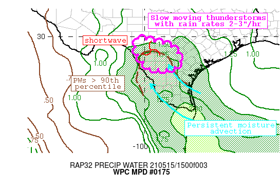
Summary...Thunderstorms blossoming beneath a shortwave will move
slowly east through the evening. Rainfall rates may approach 3"/hr
in stronger storms, and while moving less than 10 kts may produce
2-3" of rainfall with isolated higher amounts. This rainfall
occurring atop saturated soils could produce isolated flash
flooding.

Discussion...GOES-E IR imagery this afternoon indicates rapid
cloud top cooling as thunderstorms blossom beneath a shortwave
ejecting northeast from the Mexican Plateau. As this shortwave
lifts slowly northeast, it will interact with increasing
instability currently analyzed by the RAP to be 1000-2000 J/kg,
and PWs measured by GPS of 1.5-1.7", above the 90th percentile for
the date. This moisture is continuing to increase as return flow
out of the Gulf of Mexico flows up the Rio Grande Valley and into
the Texas Hill country, and forecast soundings indicate the
morning mid-level dry air has eroded which will allow for more
efficient rain rates. Additionally, a surface trough noted by wind
shifts in the regional surface observations is aligned obliquely
to this low-level flow, driving local ascent maxima across the
region.

High res guidance this afternoon is highly variable both in
placement and amounts of rainfall, but a preference towards the
HRRR, ARW, and HREFmean suggests thunderstorms developing this
aftn will expand in coverage and then drift slowly southeast at
less than 10 kts, with some backbuilding possible along the
surface trough and where Corfidi vectors are increasingly
anti-parallel to the mean flow. HREF rain rate probabilities for
2"/hr are as high as 30%, with low probabilities for 3" also
present. Additionally, the HRRR 15-min rate rate products indicate
rates of more than 4"/hr are possible for short duration. With
limited bulk shear, pulse convection is likely, and the heaviest
rainfall should occur where regeneration takes place near the
boundary/beneath the shortwave.

While coverage of heavy rainfall may be scattered, these slow
moving heavy rain rates will be occurring atop saturated soils.
14-day rainfall anomalies are as high as 300% of normal, leading
to NASA Sport 0-40cm soil moisture that is near the 95th
percentile. Recent runs of the NWM also suggest a threat for flash
flooding noted by increasing trends in both coverage and
probability for rapid onset flooding. This together suggests flash
flooding is possible, but may remain isolated due to the
anticipated scattered nature of convection.


Weiss

ATTN...WFO...CRP...EWX...

ATTN...RFC...WGRFC...NWC...

LAT...LON   29880037 29799970 29609898 29349837 29009813
            28559801 28339823 28229853 28199890 28219932
            28389982 29150044
Last Updated: 151 PM EDT Sat May 15 2021
|


