|
|
|
Product Legends
Surface Fronts and Boundaries
In addition to High and Low centers, you may see one or more of the following
eight features on a surface analysis or forecast. The definitions provided below are derived from the
National Weather Service Glossary.
 |
Cold Front - a zone separating two air masses,
of which the cooler, denser mass is advancing and replacing the warmer. |
 |
Warm Front
- a transition zone between a mass of warm air and the cold air it is replacing.
|
 |
Stationary Front - a front between warm and cold air masses
that is moving very slowly or not at all. |
 |
Occluded Front - a composite of two fronts, formed as a
cold front overtakes a warm or quasi-stationary front. Two types of occlusions can form
depending on the relative coldness of the air behind the cold front to the air ahead
of the warm or stationary front. A cold occlusion results when the coldest air is behind
the cold front and a warm occlusion results when the coldest air is ahead of the warm front. |
 |
Trough - an elongated area of relatively low atmospheric
pressure; the opposite of a ridge. On WPC's surface analyses, this feature is also used to depict
outflow boundaries. |
 |
Squall Line - a line of active thunderstorms, either continuous
or with breaks, including contiguous precipitation areas resulting from the existence of the thunderstorms. |
 |
Dry Line - a boundary separating moist and dry air masses. It
typically lies north-south across the central and southern high Plains states during the spring and early
summer, where it separates moist air from the Gulf of Mexico (to the east) and dry desert air from the
southwestern states (to the west). |
 |
Tropical Wave - a trough or cyclonic curvature maximum in the trade
wind easterlies. |
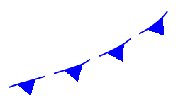
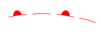
Depiction of frontogenesis and frontolysis
Frontogenesis refers to the initial formation of a surface front
or frontal zone, while frontolysis is the dissipation or weakening of a front. Frontogenesis is depicted
on WPC's surface analysis and forecast charts as a dashed line with the
graphical representation of the developing frontal type (the blue triangle for cold fronts, the red semicircle
for warm fronts, etc...)
drawn on each segment.
For example, the image below shows a forming cold front.
Frontolysis is depicted as a dashed line with the graphical
representation of the weakening
frontal type drawn on every other segment. Below is an example of a dissipating
warm front.
|